Winter Science Stratos: A Look Back at Winter 2024-2025
The Winter Science Stratos forecast model underwent comprehensive validation testing against state-of-the-art numerical and AI weather prediction systems. Here's a look at a couple of key benchmarks.
This validation study analyzes precipitation forecast accuracy across 134 ski areas throughout the western United States, comparing this custom mountain weather AI against both traditional physics-based models and cutting-edge global AI forecasting systems.
This validation uses URMA (Unrestricted Mesoscale Analysis) as ground truth, the highest resolution standardized and validated precipitation dataset available. URMA was cross-referenced against thousands of weather stations and found to provide the best balance of accuracy and data quality for backtesting at this scale. For every forecast hour throughout winter 2024-2025, each model's 6-hour precipitation accumulation predictions were compared against what actually occurred at ski area locations. The metric used is RMSE (Root Mean Square Error), where lower values indicate more accurate forecasts.
This validation focuses on 6-hour accumulation windows over a 10-day (240-hour) forecast horizon. This is a more challenging test than the longer accumulation periods (24-hour or multi-day totals) typically used in model comparisons. By testing timing precision at 6-hour resolution, the analysis evaluates not just whether models can predict the right amount of precipitation, but whether they can predict when it will fall. This matters for mountain operations, avalanche forecasting, and trip planning where timing is critical.
At longer lead times, all models begin to lose skill in predicting precise 6-hour windows. This isn't a failure of the underlying models, but rather a fundamental limit of atmospheric predictability at fine temporal resolutions. By day 10, even the best forecasts approach climatological averages for these short time windows, though they still provide value for longer accumulation periods.
This is a true backtest comprising 385,020 individual forecasts. No cherry-picking storms or favorable conditions. This is every forecast, every day, across an entire winter season at more than a hundred mountain locations.
The Global Forecast System (GFS) is the most commonly used model in ski weather forecasting apps. It's free, readily available, and runs four times daily with forecasts extending 16 days into the future. Because of its accessibility, GFS forms the backbone of most consumer weather apps and many forecasting services.
But being widely used doesn't mean it's optimized for mountains. GFS is a global model designed to predict weather patterns across oceans, deserts, and everything in between. Mountain weather, with its complex terrain, orographic effects, and rapid elevation changes, is just one small piece of what it's trying to solve.
Released just weeks ago, WeatherNext 2 from Google DeepMind represents the bleeding edge of global AI weather prediction. It's currently winning across nearly every forecasting benchmark and has set new standards for what AI can achieve in atmospheric science.
WeatherNext 2 is a true state-of-the-art system. It's trained on decades of global weather data and can generate remarkably accurate forecasts for locations around the world. Importantly, WeatherNext 2 is a 64-member ensemble forecast, meaning it generates multiple possible future scenarios to capture forecast uncertainty. Ensemble forecasts are inherently more accurate than single deterministic predictions because they account for the chaotic nature of atmospheric dynamics and provide probabilistic guidance rather than a single outcome. If you want to know what the best general-purpose AI weather model can do in 2025, this is it.
The Climatology baseline represents what you'd predict if you simply used long-term climatological averages, essentially assuming every day matches historical norms. It's a flat line at 2.97 RMSE because it doesn't adapt to actual forecast conditions. Any useful weather model should dramatically outperform this baseline.
Here's where things get interesting.
While WeatherNext 2 has to forecast for the entire planet (oceans, tropics, polar regions, urban centers, and everything in between), Winter Science Stratos is purpose-built exclusively for mountain weather regimes.
Like WeatherNext 2, Stratos is a full 50-member ensemble forecast, leveraging the power of probabilistic prediction to capture uncertainty and improve accuracy. Stratos leverages advances in AI forecasting from the behemoths of Google, ECMWF, and NVIDIA while focusing exclusively on mountain forecasts. Rather than starting from scratch, Stratos uses boundary conditions from state-of-the-art AI and numerical weather model inputs and applies custom AI specifically trained on mountain weather patterns: orographic precipitation, elevation-dependent processes, terrain-forced winds, and the unique atmospheric dynamics that make forecasting in alpine environments so challenging. Critically, the Stratos model was trained exclusively on data prior to winter 2024-2025, ensuring this validation represents true out-of-sample performance on conditions the model had never seen during training.
The result is a model that understands mountains in ways that global systems simply can't. It's the difference between a generalist and a specialist.
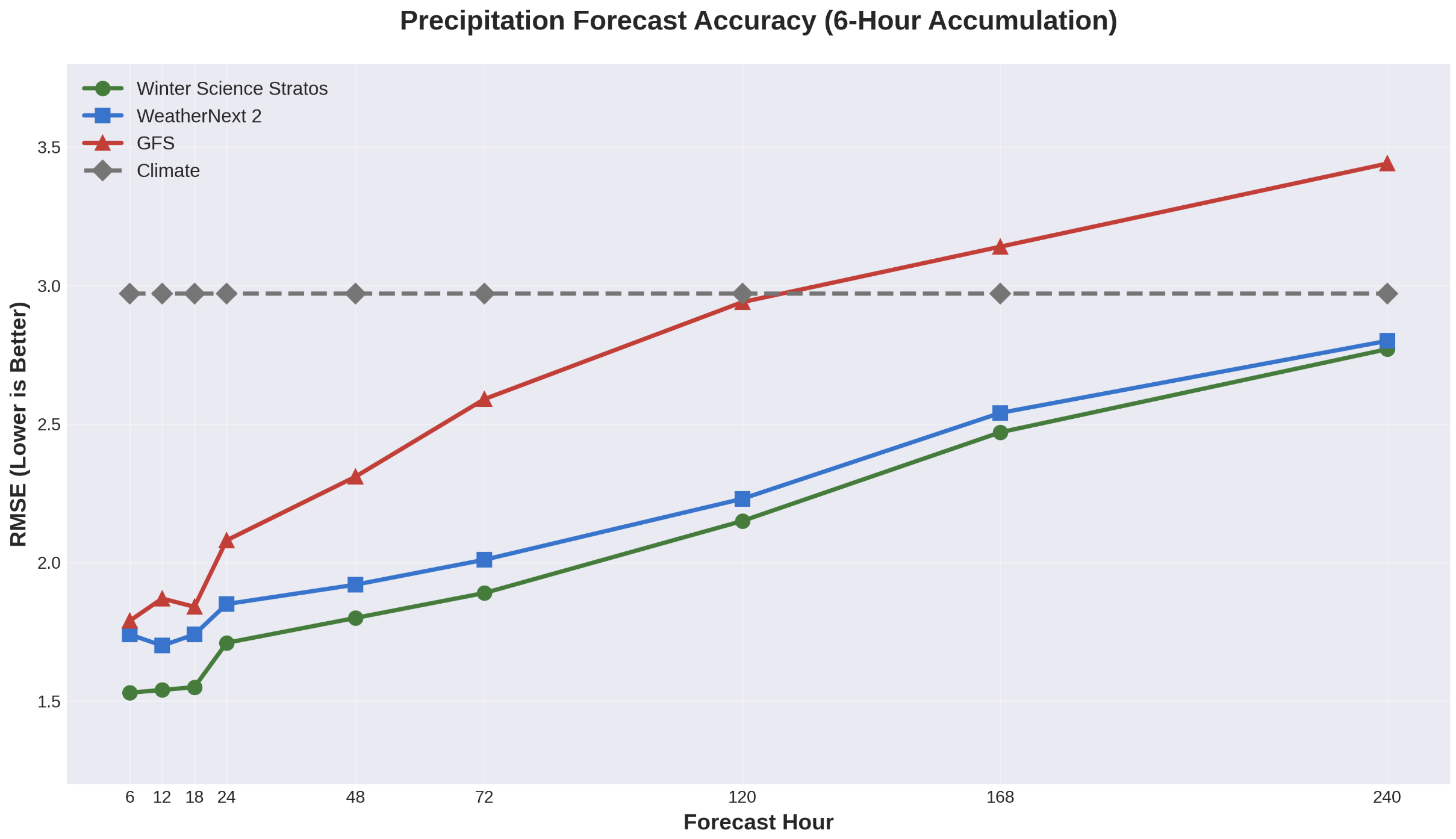
The data speaks for itself:
Winter Science Stratos: 1.93 average RMSE
WeatherNext 2: 2.06 average RMSE
GFS: 2.44 average RMSE
Climatology: 2.97 average RMSE
Stratos outperforms even Google DeepMind's state-of-the-art global AI model across all forecast lead times. By 240 hours (10 days out), most models show significant accuracy degradation, but Stratos maintains its edge through intelligent multi-model fusion and mountain-specific learning.
Looking at individual resorts adds further context to the overall picture. The Stratos forecast achieved lower overall RMSE across all time horizons than GFS at 98.5% of locations. It outperformed WeatherNext 2 at 70.4% of locations. Critically, at every single location where Stratos didn't achieve the lowest RMSE, it remained highly competitive. No location showed RMSE values higher than 7% above the WeatherNext 2 model. This consistency matters: Stratos delivers superior accuracy nearly everywhere, and where it doesn't win, it's never far behind.
Winter Science Stratos demonstrates remarkably consistent precipitation forecasting across all lead times when verified against URMA observations throughout the winter of 2024-2025.
Bias measures the systematic tendency of a forecast model to consistently over-predict or under-predict. A positive bias means the model tends to forecast too much precipitation on average, while a negative bias means it tends to forecast too little. Zero bias indicates no systematic tendency in either direction.
Winter Science Stratos maintains minimal bias across all forecast periods, from 6 hours out to 10 days (240 hours). The bias ranges from -1.7% to +3.4% across all lead times, clustering tightly around zero with no clear trend as forecasts extend further out.
For a storm expected to drop 12 inches of snow, a 3% bias translates to just 0.36 inches. For a larger 24-inch storm, even the 3.4% bias (the highest shown) represents only 0.8 inches of systematic error.
Stratos shows no systematic tendency to over-forecast or under-forecast precipitation as lead time increases. The model maintains the same neutral bias whether predicting 6 hours or 10 days ahead, meaning forecasts won't consistently run wet or dry as the forecast period extends. This reliability allows users to trust that forecast amounts represent the model's true best estimate, not a systematically biased prediction.
You may have noticed a common pattern with extended precipitation forecasts: those promising powder days a week out often seem to diminish as the event approaches. While there are various theories about this phenomenon (and different motivations across forecasting services), the reality is likely not nefarious. It's genuinely challenging to manage the statistical properties of large ensemble forecasts over extended periods, and ensemble means can drift toward over-forecasting at longer lead times.
Significant effort went into ensuring Stratos maintains consistent bias characteristics across all forecast horizons. Rather than showing systematic wet bias in the extended range that could create false excitement about incoming storms, Stratos was specifically tuned to remain neutral whether forecasting tomorrow or ten days out. This means when Stratos shows a significant storm in the extended forecast, you can trust it's not systematically inflated compared to the near-term outlook.
Winter Science Stratos demonstrates exceptional temperature forecast consistency across all lead times when compared to 24-hour forecasts. This analysis examines Pacific Northwest ski areas throughout the winter of 2024-2025.
This measures how much longer-range forecasts differ from the 24-hour forecast for the same valid time. For example, comparing what the 7-day forecast predicts for next Tuesday versus what the 1-day forecast predicts for that same Tuesday. This reveals whether the model systematically drifts warmer or colder as lead time increases.
Winter Science Stratos maintains remarkable consistency across all forecast periods, from 1 day out to 15 days (360 hours). The temperature delta ranges from -0.02°F to +0.30°F across all lead times, staying well within half a degree of the 24-hour baseline forecast.
The largest delta occurs at the 7-day forecast (168 hours) at just 0.30°F warmer than the 24-hour forecast. Even at the 15-day range, the difference is only 0.15°F. These variations are essentially imperceptible in practical forecasting terms.
Winter Science Stratos shows no systematic tendency to drift warmer or colder as forecast lead time increases. Unlike traditional numerical weather models that often exhibit a cold bias in extended forecasts, Stratos maintains neutral temperature predictions whether forecasting 1 day or 15 days ahead. You won't see forecasts that come in cold a week out only to warm up as the event approaches. Users can trust that extended forecasts won't systematically run colder (or warmer) than short-range predictions for the same event.
When you're planning a trip, checking avalanche conditions, or making operational decisions for a ski resort, forecast accuracy directly translates to better decisions. A few millimeters of precipitation difference might seem small, but in mountain environments it's the distinction between powder and rain, between a stable snowpack and an avalanche cycle, between bluebird conditions and a whiteout.
Winter Science doesn't just predict weather, it decodes mountains. The forecasts are built by snow professionals who understand what matters in alpine terrain, powered by AI systems trained specifically for the environments where users live and work.
This validation proves that specialized, mountain-focused AI can outperform even the world's most advanced global forecasting systems. It's not magic—it's purpose-built intelligence applied to the specific problem of mountain weather.